3 km plus a small tributary, Dallimore Creek, 400 m.
Three Major Tributaries with their own sets of pages: Castle Frank Brook, Yellow Creek and Mud Creek.
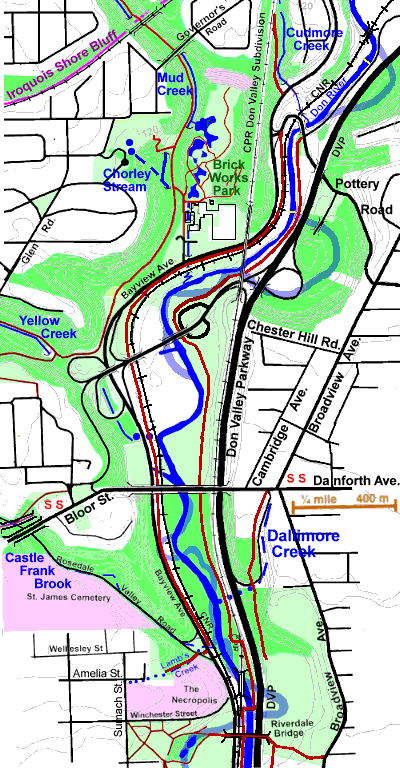
The stretch, from Pottery Road to the Riverdale Bridge, is here called the Ravines Reach because three major tributaries, Castle Frank Brook, Yellow Creek and Mud Creek, each with a significant ravine system crossing old (pre 1998) Toronto entered here and a fourth smaller tributary, also with a ravine, Cudmore Creek, entered just north of Pottery Road. The Don has been re-routed through parts of this reach, most notably south of The Prince Edward Viaduct in late 19th and early 20th centuries as part of the so- called Don Improvement, and to the north in mid 20th century to accommodate the Don Valley Parkway. The old course of the river is shown in light blue on the map below.
There are many bridges across the Don River and this stretch is no exception. To see a list with pictures of the bridges along The Don here, go to Ravines Reach Bridges.
The woodlands along the Don Ravine and the tributary ravine add much to the City. In the year 2000 The City of Toronto engaged the Toronto and Region Conservation Authority to study the natural heritage features of the newly amalgamated city. See the “City of Toronto Natural Heritage Study”. An overlay showing vegitation communities for the map can be seen by clicking as noted below.
While originally this area drained directly to the Don River, direct access is now blocked by streets, railroads and The Don Valley Parkway; so most storm water must pass through various culverts and small storm sewers to reach the river. There are at least four storm sewers and six combined sewers plus a number of culverts emptying into this stretch of the Don. The map below shows the significant ones. To get an idea of how storm water is managed, see RiverSides’ Water in the City Walk. Sanitary sewage flows to the Ashbridge’s Sewage Treatment Plant. Some of the main sewers can be seen by clicking as noted below.
Click here to see sewers. Double click to remove.
To see the City of Toronto's Natural Heritage Study vegetation communities, click here. Double click to remove.
Walking The Don from Pottery Road Bridge to Riverdale Foot Bridge
Four routes are described:
- West of Bayview
- Between CN Rail and Bayview
- Lower Don Trail, west of the DVP and generally east of the Don River
- City streets and park trails east of the DVP
The City’s “Don Valley Hills & Dales” Discovery Walk follows the latter two routes.
Route 1 - West of Bayview
Start by crossing Bayview Avenue at Pottery Road with the lights. Here one can follow Bayview on the paved shoulder north to the Cudmore Creek Ravine (and further to Moore Ave). or south to Brickworks Park, where we leave Bayview and take park roads and trails past the end of Mud Creek to the trail following the route of the former Beltline Railway and the “Central Ravines, Ravines, Beltline & Gardens” Discovery Walk. The woodland on the slope above is notable.
Follow this trail into Park Drive Reservation Ravine to a sign that points out Milkman’s Lane. Milkman’s Lane got its name as this road was used by milkmen who got milk from the farms that used to be in the Don Valley and delivered it to homes in the city. Take Milkman’s Lane to Cragleigh Gardens Park, noting that the forest we walk through on the slope of the ravine is especially fine including: Sugar Maple, Manitoba Maple, Ash, White Birch, Beech, Oaks, Hemlock. Cragleigh Gardens Park contains many fine old White & Red Oaks. Cross the park to the south-east corner; and take the walkway to Castle Frank Road, and follow it to Bloor Street and Castle Frank Subway Station. Along this street note the cluster of Kentucky Coffee trees at Hawthorn Gardens and the historic house at the end of Drumsnab Road, Drumsnab which is probably the oldest house in Toronto that is still used as a private dwelling.
At Castle Frank Subway Station take the path just north of the station down to Rosedale Valley Road. This is what is left of the first road that led from Parliament Street into this end of Rosedale. For more about this ravine see Rosedale Valley Reach of Castle Frank Brook. Follow Rosedale Valley Road nearly to Bayview Avenue to a path that follows a little draw up into Wellesley Park. This is all that is left of Lamb’s Creek, known in the nineteenth century as the most polluted stream in Toronto. Peter Lamb and his son Daniel had a tannery and manufactured stove blacking here from 1849 to 1888. On the south-east is St James Cemetery and the ridge to the north-east was the location of Castle Frank, the summer home of the Sir John and Lady Simcoe. Take the path up through Wellesley Park past the Necropolis to Amelia Street and the site of Lamb’s Glue and Stove Blacking Factory. From here follow Sumach Street south to Riverdale Park where one takes park trails through Riverdale Farm to the Riverdale Foot Bridge. To continue on down along the Don River, see The Channelled Don.
Route 2 - Between CN Rail and Bayview
This trail can be followed south to Rosedale Valley Road, where to continue south one has to leave the valley for a bit. The quality of this trail varies considerably. It starts as a dirt trail that leads south off Pottery Road just east of Bayview. After passing the CPR bridge it follows the paved shoulder of Bayview past the Brickworks. A separate paved trail begins opposite the entry to a works building at the Binscarth Ravine. Just before it changes to a board walk to go under the Bloor/Bayview Off Ramp to the DVP, note the Salt Dome to the east. After this the paved trail resumes. It may not be too noticeable, but one of Toronto’s snow dump sites is located here between the CN Railway and the Don River south of the Bloor/Bayview Off Ramp. Just north of the Prince Edward Viaduct, note where the Spadina Trunk Storm Sewer empties into the Don River. Finally a bit south of the Prince Edward Viaduct the trail returns to the paved shoulder of Bayview which it follows as far as Rosedale Valley Road. Here one takes the path, noted above in Route 1, up through Wellesley Park past the Necropolis to Amelia Street and the site of Lamb’s Glue and Stove Blacking Factory. From here follow Sumach Street south to Riverdale Park where one takes park trails through Riverdale Farm to the Riverdale Foot Bridge. To continue on down along the Don River, see The Channelled Don.
Route 3 - Lower Don Trail, Pottery Road to Riverdale, west of the DVP and generally east of the Don River
This is paved trail all the way and a favoured route for bicycles and joggers. Except for the last 100 m or so, this trail lies east of the Don River. It is also part of the “Don Valley Hills & Dales” Discovery Walk. It starts just east (south) of the Pottery Road Bridge. This is a double span bridge. The span carrying east-bound traffic is quite recent, but the west-bound span is much older. It was built in 1928 and refurbished in 1988. About 300 m down the trail note the rapids. This is where one of the Lamprey Wiers was modified. Pass under theCPR Railway bridge. This caries the CPR Don Valey Subdivision over Don River on its way from Leaside to Union Station.
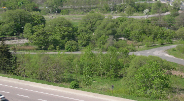
As one approaches the Bayview Bloor Ramp one of Toronto’s Salt Domes comes into view. Past the Ramp, across the Don River the outlet for Yellow Creek can be seen. (picture) To the east at the foot of the slope from the CPR, the Helliwell’s Hill Wetland Restoration site can be seen. West of the river and between that and the CNR is located one of the Snow Dump Sites in the Valley.
Just befor passing under the Prince Edward Viaduct, note the out fall for the Spadina Storm trunk Sewer across the river. (picture) Next we pass Chester Springs Marsh, a major BBTD restoration project. Further on the trail passes under the CNR though a tunnel. and then we pass the site of the former Winchester Bridge, for many years, before the construction of the Prince Edward Viaduct, the most northerly crossing of the Lower Don River. Shortly before arriving at the Riverdale Foot Bridge, the trail crosses the river on a small bridge to the west side. To continue on down along the Don River, see The Channelled Don.
Route 4 - City streets and park trails east of the DVP
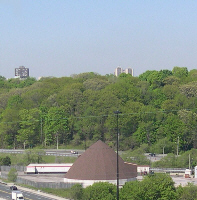
From Pottery Road and the Don River follow another segment of the “Don Valley Hills & Dales” Discovery Walk. Go up Pottery Road to Broadview Avenue, thence south and west along Chester Hill Road, to the the Chester Hill Lookout. This provides a splendid panoramic view of the valley.
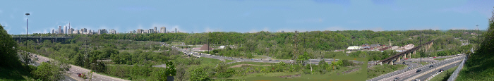
Among the points of interest one can see from here are Prince Edward Viaduct, the high buildings of downtown Toronto, CN Tower, the Salt Dome, Helliwell’s Hill Wetland, and the Brickworks.
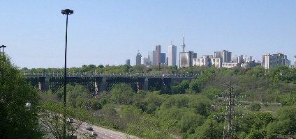
Prince Edward Viaduct, the high buildings of downtown Toronto, CN Tower and the Salt Dome.
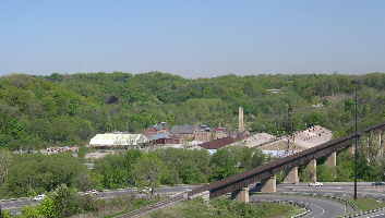
The Don Valley Brickworks
Helliwell’s Hill Wetland
Following the Discovery walk signs, take Thorncliffe and Cambidge Avenues to the Danforth. This is an opportune time to visit Prince Edward Viaduct and see the views of the Don Valley from it. Bloor Street, the Viaduct, and Danforth Avenue are busy; it is better to cross at the lights (at Castle Frank Road and at Broadview) rather than ducking traffic to get across the highway in between.
Go to theSW corner of Broadview and Danforth Avenues and and west to the DVP on Ramp cross it and take the trail with Discovery Walk signs south past the City Adult Learning Centre. The path follows the small ravine of the former Dallimore Creek to where it turns west towards the Don River. Dallimore Creek, which was probably fed by springs was only about 400m long and entered the Don River through a marshy area called Dallimore Swamp. At one time, Don Mills Road took advantage of this cut in its run from the Winchester Street Bridge to Broadview. This small valley now accomodates an on-ramp to the DVP. The Taylor Tollgate was located near the top of this valley.
The trail crosses the valley on a foot bridge and by a series of ramps it descends to the Don valley floor. Follow this trail through the woodland to the open park, where one can walk across the grass to the Riverdale Foot bridge. The young woodland on the slope at the north end of the open parkland was the first restoration effort of the Task Force to Bring Back The Don. Beside the trail, at the foot of the wooded slope is the East Riverdale Wetland, a small wetland established in a damp area of this park.
While walking to the Riverdale Foot bridge, note the small area of wet ground on the east slope of the park, the East Riverdale Wet Meadow, where native wetland plants have been encouraged by the Task Force to Bring Back The Don.
Should one chose to walk down Broadview to Riverdale Park East, note 660 Broadview Ave., now part of Montcrest School, but originally the home of William Peyton Hubbard, Toronto’s first City Councillor of African descent. One can also follow RiverSides self guided walk about Water In The City.
At the Riverdale Foot bridge one has the option of continuing down the Lower Don Trail. See the Channelled Don.