December 2001
In the year 2000 The City of Toronto engaged the Toronto and Region Conservation Authority to study the natural heritage features of the newly amalgamated city. The City wished to manage human activity in ways that would protect, restore and enhance the City’s natural heritage. This would be part of the planning process leading to the new City of Toronto Official Plan. This analysis was to include an inventory of ecological information and “a tool to identify a natural heritage system within a functional framework that is designed to address biodiversity and ecosytem needs, while recognizing urban context and multiple-use values.”
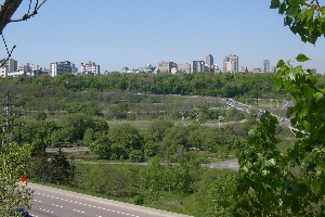
The area of natural habitat and the quality of the vegetation communities is impressive for a large urban area.
Information from the terrestrial landscape resource layers has been used to prepare the vegitation maps attached to the Lower Don reach pages.
The resulting report and its acompanying GIS database provided an inventory of ecological information available to the City, that describe the natural heritage system. The GIS database has over 40 ecosystem resource layers, including information on earth sciences, aquatic, and terrestrial information. This inventory can be used in different ways such as describing and evaluating conditions, defining the natural heritage system or to model for potentially healthier conditions. Toronto Region Conservation Authority carried out this study in collaboration with the Natural Heritage Study Technical Working Group, whose members were officials from Economic Development, Culture & Tourism, and Urban Development Services as well as from the Authority. This report is not available on line, but may be purchased in book from from the City. www.toronto.ca/publications
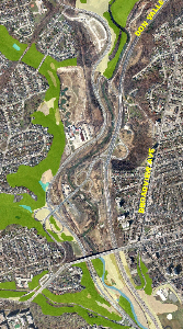
Portion of Vegetation Map for Don Valley
The terrestrial landscape analysis found that there are aproximately 8,600 hectares of natural habitat in the City of Toronto, covering 13.5 percent of the total area. This habitat is unevenly distributed, with most of the larger patches located in the Rouge River and Highland Creek watersheds. The majority of patches are less than five hectares and are convoluted rather than simple in shape. As a result, forest interior, an indicator of quality habitat, is rare in the city. The surrounding urban areas present great strains, frequently leading to habitat disturbance and degradation. While Toronto does not have a completely healthy terrestrial natural heritage system, the total area of natural habitat and the persistence vegetation communities and flora species of concern is impressive for a large urban area.
Using the Ecological Land Classification System for Southern Ontario, 240 vegetation communities were identified within the City. Although most are common for the region, some rarities are still represented within the city, including tallgrass prairie and savannah remnants. Unfortunately, many areas are threatened by invasive exotic plants and an overall decline in ecosystem health, so that continued protection and restoration efforts are require to maintain and improve conditions.