1.5 km of Castle Frank Brook, from St. Clair Ave. To CPR main line.
The Nordheimer Ravine runs through one of the fine residential neighbourhoods of the former City of Toronto from St. Clair Ave. W. near Bathurst past the Iroquois Shore Cliff at Poplar Plains Road to the CPR tracks at Davenport Road. This area contains one of the finest stands of old Oaks in the city. The Spadina Storm Trunk Sewer follows this ravine and sanitary sewers feed to the Core Interceptor Sewer via a trunk sewer that roughly follows the old stream as far as Parliament Street.
Click here to see sewers. Double click to remove.
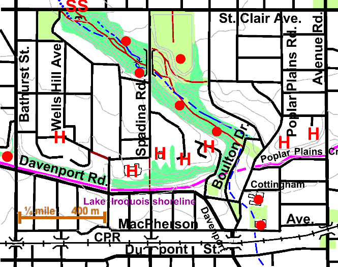
The Nordheimer Ravine can be entered by a small trail starting at the corner of St. Clair Ave. and Wells Hill Ave. It can also be reached by a path just east of the Subway Station entrance on the south side of St. Clair Ave. Going down the path we are on fill covering the subway. Some of the small trees we see were planted and some have established themselves naturally. The latter are by no means all native trees; many small elms can be seen which are probably introduced species such as Siberian Elm. Manitoba Maple, Cottonwood, Ash, and Red Oaks were noted. Further down the path, there are several large clumps of Sumac that were planted after the subway was built. Continuing down the valley, note the old growth, Oaks with occasional White Pine, Maple and Ash, on the upper slopes. There are many fine old Oaks in this part of the city to the north of the Iroquois Shore Cliff, from Moore Park in the east, nearly to The Junction in the west. Red and Silver maples, Honey Locusts, and other species can also be seen along the ravine.
The main path splits into two for short distance. To the north of the paths, we observe that a small stream with marshy areas has become established on the fill similar the one in the Cedarvale Ravine. One of the Task Force to Bring Back The Don’s small habitat restoration sites, The Nordheimer Skunk Cabbage Patch lies to the north side of the trail here. It was planted with moist and wet understory plants such as Skunk Cabbage, Marsh Marigold, Sedges, several Ferns, Spice Bush and Mountain Maple starting in the spring of 1999, with the objective of improving habitat for butterflies, for birds such as Yellow Warbler, Common Yellowthroat and Grey Catbird and possibly for amphibians.
Crossing a small foot bridge we come in sight of the emergency exit to the subway which played an important part in rescue operations after the August 1995 subway catastrophe.
Past the Spadina Bridge, we pass through the grassy south end of Winston Churchill Park which is largely located on the St. Clair Reservoir to the north. In this part of the ravine there are several areas that have been naturalized and recently planted with trees. Continuing down the ravine, we enter Roycroft Park; note the occasional White Pine Hemlock and Walnut associated with the upper slope White and Red Oaks Maple and Ash. Willows are found in the lower damper places. One will pass two small wetland restoration projects executed by TRCA & The Task Force to Bring Back the Don; first the Glen Edyth Wetland Restoration and then the Roycroft Wet Forest Restoration. Is there also an opportunity to restore the stream which is here reduced to little more than a ditch on the north side of the trail? Much of the valley wall is dominated by Norway Maple. This is a good place to observe how dense stands of Norway Maple result in eroded slopes.
On the ridge to the south above the Roycroft Wet Forest Restoration stood two noted early houses. From 1818 to 1872 this hill was occupied by Russell Hill, built by Admiral Augustus Warren Baldwin, a member of the family that owned much of the land and built many of the early houses in this part of what is now the City. In 1872, Samuel and Edyth Nordheimer replaced Russell Hill with Glen Edyth, their grand house which stayed here until it was demolished 1929. A landscape architect was brought in from Cleveland to design the twenty-three acres of gardens. He dammed Castle Frank stream to create a pond and waterfall. Some of the landscaping was still noticeable in the 1940s. Click for some of the writer’s memories of this ravine and other places in Toronto in the 1940s.
At Boulton Drive we reach the place where Castle Frank Brook entered glacial Lake Iroquois. The fossil shore cliff of this glacial lake is located immediately to the north of Davenport Road to the west and of Poplar Plains Crescent & Alcorn to the east. Here the Spadina Storm Trunk Sewer leaves this valley, crossing from Avenue Rd to Yonge under MacPherson Ave., heading for Yellow Creek east of Mount Pleasant Rd. On the top hill and just east of Poplar Plains Road, stood Rathnelly (built in 1851) the home of William McMaster whose name lives on in McMaster University. Poplar Plains Road probably marks the route of a prehistoric trail.
Follow valley down Boulton Drive to Cottingham Rd. On the west is Glen Edyth Parkette, the upper level of which is close to the elevation of Lake Iroquois. Trees here include Norway Maple, Linden and Green Ash on the upper level and White Ash and Crack Willow in the lower. Take Cottingham Rd. over to Poplar Plains Road. Two historic buildings are in the former stream bed: High Level Pumping Station and Hydro Sub Station H. Follow the stream through their grounds. The High Level Pumping Station was built in 1906, on the site of the previous Yorkville Waterworks, to provide water to the new part of the City, then expanding north above the hill. It was enlarged in 1910. It now houses the Central Control for pumping all Toronto water.
Hydro Sub Station H on MacPherson; was built in 1910 and expanded in 1924. It provides power to 12,500 customers from Kilbarry Rd. to Charles St. and from Spadina Road to Mount Pleasant Rd. Its total load is 1212.7 Mega Volt Amps. The playground between these buildings marks the site of an old pond. Take MacPherson to the Davenport underpass and down to Dupont under the CPR Railway, noting the industrial area that developed along the rail line. Continue on through the Yorkville Reach.