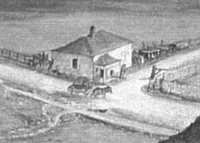
To finance the early roads the Government and private firms collected tolls. The little building seen in this picture (from a painting by Arthur Cox 1875) at the south-east corner of Davenport and Bathurst was one of the cottages built to house tollkeepers.
This particular tollhouse, which had been moved to several locations in the area, was discovered and was stored at the TTC’s Wychwood Yards until it was moved, in July 2002, to the small park at the north-west corner of Davenport and Bathurst across from its original location. The cottage was given by the owners of the property where it last stood to the Community History Project which, assisted by the Toronto Historical Board, has raised funds and enlisted volunteers to save the cottage, have it moved and restored. Now that it is in a permanent location close to where it started out, restoration has begun. The plan is to restore to it original condition; fit it out with displays about 19th century transportation, and have space available for community use.
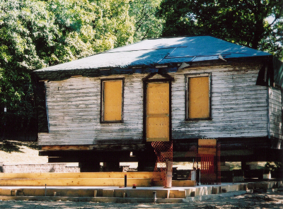
Tollhouse now on site
The cottage may date from as early as 1827 or 1830. It is of plank construction and an exceedingly rare example of this type of building. The only other known building of plank construction is the Joseph Schneider House in Kitchener. The planks in this cottage are, on average, 2 inches thick and up to 30 inches wide, vertically aligned. They have been covered outside and inside. Two bits of the original interior walls remains. It has mortise and tenon construction with hand split lathing for plaster. It was probably built by the government of Upper Canada to collect money to help with the maintenance of existing roads and the construction of new roads. The government system failed and was replaced by one where privately owned companies bid for contracts to build specific sections of road and recoup their investment through the collection of tolls. This system too was abolished in 1895. Except for one sign at Black Creek Pioneer Village, this little cottage is the only remnant left in Ontario from the days of toll and plank roads. Time and further research may reveal other relics of that era, but, for now, this cottage the only early tollhouse left .
Should you wish to contribute to this project either by volunteering or by making a donation, please call the The Community History Project 416 515 7546.
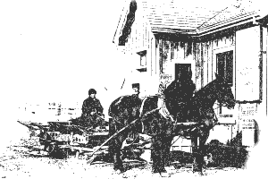
Toll Gate at Dundas
Other Toll Gates existed. The Taylor’s & Don Mount tollgates in the Riverdale area have been marked on the maps of that area.
Early Roads
Davenport Road is one of the oldest, if not the oldest road in the vicinity of Toronto with a history dating back to the time when the great ice sheets were melting. It was a trail used by Native people and early settlers, and is shown on a map drawn by Elizabeth Simcoe in 1796.
Vaughan Road was privately built by the Yorkville and Vaughan Road Company, in 1850, to open up the farm lands along Dufferin Street in York and Vaughan Townships. Originally Vaughan Road started at Yonge St. and followed Davenport to Bathurst St and thence up to and along the present Vaughan Rd. to Dufferin St and north into Vaughan Twp. Its route was based on earlier trails established by the Native People. It provided the first road access to the triangle of high land between the Davenport Escarpment on the south, and the Cedarvale and Nordheimer Ravines to the north-east.
Poplar Plains Road and its continuation north along Forest Hill and Old Forest Hill Roads are very likely based on an old native trail. I can picture this trail north of the Iroquois Bluff being used by Palaeo-Indians to move from their fishing activities on Lake Iroquois to the Mammoth hunting grounds around the marshy ponds along the early Yellow Creek. Poplar Plains Road was known as the “Road to Yonge Street” as 18th century traffic avoided the difficult part of Yonge Street between Davenport Road and The Second Concession North of The Bay (St Clair Ave.), crossing Castle Frank Brook and up the Iroquois Bluff. Old Forest Hill Road was also known as the Serpentine Road.
**Don Mills Road and the Taylor Tollgate **Like other former pioneer roads Don Mills Road was not always as it is today. In December 1841, inhabitants of the valley decided to improve the access to the City of Toronto and over the next year, by voluntary labour of men and teams, constructed what was to become known as Don Mills Road. It got its name as it served several grist, saw and paper mills along that stretch of the river. From where it crossed the Don River it followed what is now Winchester Street west to Sumach Street, and from The Don east, its route followed, the existing on-ramp to the DVP, Broadview, O’Connor to approximately where Don Mills is now and crossed the Don River again at the Forks to continued north. In later years, there were some adjustments, especially when the DVP was constructed.
In 1844, the Don Mills Road Company was formed to improve this road. It planked Winchester Street as far as Parliament Street. To pay for these improvements, it established a toll gate near where Broadview crosses The Danforth now.
Pottery Road was once called Todmorden Road and ran from Don Mills Road (now Broadview) to Moore Avenue. As a result of the construction of the Bayview Extention and the DVP, that part of Pottery Road from the Don River to Moore Avenue was abandoned.
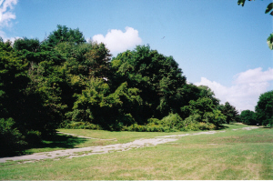
Abandoned stretch of Pottery Road (west of Bayview Avenue)
Thanks to The Community History Project, Don Valley Legacy by Ann Guthrie, Terry McAuliffe, and others for information about early roads.