For the last two million years or more, large parts of the northern hemisphere, all of Antarctica and many mountain chains on other continents have been covered and recovered by ice sheets. The surface of most of Canada has been shaped by the advancing and retreating of these glaciers. Most of Great Lakes’ basins and most other Canadian lakes, both large and small, were carved out by the moving ice. Soil and rocks were scooped off the Canadian Shield and deposited over southern parts such as Toronto.
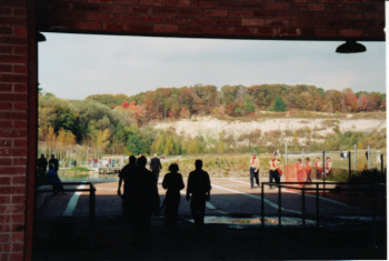
The North Wall, seen from the heritage buildings
Much of our geological history has not only been shaped but also been annihilated by glaciers. Each advancing glacier destroyed most of the evidence of earlier ice sheets; however, here and there, deposits from earlier stages have escaped. From them we can get a glimpse of what happened. The Don Valley Brick Works Park is one of those windows into the history of the last million years. It is world famous for the geological history revealed by the sediments of the north quarry wall (picture above and diagram below). This is one of the very few sites where climate change and the environment can be studied between the last two major glaciations.
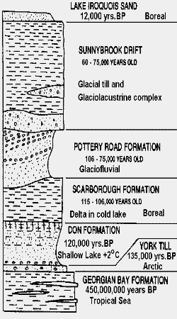
At the bottom are the limy shales of the Georgian Bay Formation, deposited in a tropical sea 450,000,000 years ago. This is the bedrock of Toronto. In the aeons since it was formed North America has drifted north, the land has been lifted out of the sea and considerable rock eroded.
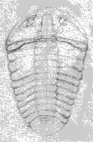
Drawing of an Ordivician Trilobite, Calemene meeki
Just above the bedrock is a thin glacial deposit called the York Till, laid down during an earlier glaciation, that ended about 135,000-years ago.
Above this glacial deposit and below more recent glacial deposits is a sandy layer, called the Don Formation, containing fossils that indicate that, about 120,000 years ago, the climate of the Toronto area was slightly warmer than at present. This was proof that there were at least two major ice advances which were divided by interglacial intervals with moderate climate, similar to the present. This warm weather deposit contains fossils of molluscs, trees and other life, some of which are found in the Toronto area today such as Sugar Maple White Oak and Hemlock and others such as Papaw, Blue Ash and Shagbark Hickory and Southern White Cedar, that are now found further south. It also contains fossils of extinct species such as the giant beaver. It would appear that a river (a predecessor of The Don) flowed into a lake in the Ontario basin that was a bit higher (10 m) than the present lake.
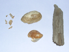
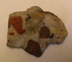
Some interglacial fossils, Pleurocera, Ptychobranchus, Pleurabema and Hemlock.
This lake is called Lake Coleman by geologists in honour of A. P. Coleman, who taught Geology at the University of Toronto from 1891 to 1922. He not only described this interglacial deposit, but discovered some very ancient glacial deposits in Northern Ontario that are 2.4 billion years old.
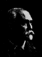
A. P. Coleman and Bruce Conglomerate (Glacial till 2.4 billion years old)
Continuing our examination of the Brickworks north quarry wall, above the warm weather Don Beds we see a deposit of finer materials laid down 115-106,000 years ago, called the Scarborough Formation. These beds are best seen at the Scarborough Bluffs and appear to be the delta of a large river which was possibly fed by meltwater from the growing Wisconsan Ice Sheet. This indicates a higher lake and beetle fossils found in this formation indicate a cooler Boreal climate. A growing ice sheet had blocked the St. Lawrence, causing a high level lake similar to Lake Iroquois. In early days, the clays in the Scarborough Formation became Toronto’s most desired source of brick and pottery clay. The upper part of this formation sometimes called the Pottery Road Formation (106-75,000 years ago) is more indicative of glacial conditions.
Higher and nearly to the top is found the Sunnybrook Drift (60-75,000 years ago) an assemblage of glacial till, glaciolacustrine and mixed deposits that indicate a high level lake and the presence or near presence of the Wisconsinan Ice Sheet. Not present in the north quarry wall, but at the top of the Iroquois shore cliff a short distance north (and covering much of the GTA) is the Halton Till, debris left by the final push of the great Wisconsinan Ice Sheet.
20,000 years ago Wisconsin Ice Sheet pushed as far south as the Ohio Valley, reaching its greatest extent about 18,000 years ago. During the time of maximum ice, (from about 20.000 years to 14,000 years ago) the ice grew to a thickness of two kilometres over Toronto.
The north quarry wall is capped by later sandy beach deposits about 12,000 years old formed by the waves of Lake Iroquois cutting its shore cliff after the ice sheet finally withdrew from Toronto.
Other pages in this series on Toronto’ Ice Age
- Don Valley Brick Works Quarry - North Wall
- Before the Ice Age
- How The Glaciers Started
- The Great Delta
- Maximum Extent of the Ice Sheets
- The Story From The Lakes
- The Story of the Trees
- Early Stages of the Retreat of the Ice Front
- Drumlins and Flutings
- Lake Iroquois & its shore cliff
- The Wide Valley of the Lower Don
- Geology References