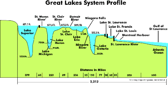
Besides the positive evidence left by the glaciers, such as moraines and out- wash deposits, there is negative evidence. The depths of the Great Lakes tell such a story. The lower Great Lakes were not present before the Ice Age. They were dug out by the ice sheets advancing off the hard Precambrian shield onto the relatively soft Palaeozoic rocks of the central plains. As the latter rocks varied in hardness from the soft shales, such as are found at the Brick Works to the hard dolostone that caps the Niagara Escarpment, the depth to which the lakes were excavated varied. The depth also varied with the duration of the glaciation. The following {diagram} plots the depth of the Great Lakes.

Lake Superior’s depth may not be fully attributable to the glaciers as its basic shape comes from a very ancient (1.1 billion years) rift valley. Lake Vostok is the largest of many freshwater lakes that lie hiden under the Antarctic ice sheet. It is about the size of Lake Ontario. For more about this lake google “Vostok.” It is possible that Lake Superior was such a subglacial lake during the glaciations of the Pleistocene.
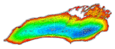
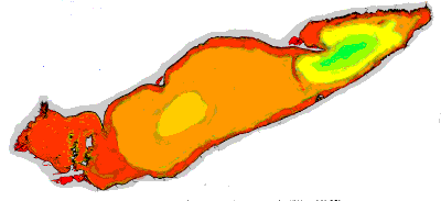
It is reasonable to assume that Lake Erie did not experience the amount of glaciation that the other lakes did. Looking at contour maps of the bottom of the lakes, such as the following {two maps} showing the bottoms of Lake Erie and Lake Ontario, one can conclude that the ice lobe that moved up the St. Lawrence, then over the Lake Ontario basin and finally over the Lake Erie basin spent more time in the eastern end of Lake Ontario and much less time over the western end of Lake Erie.
Lake Ontario
Max.Depth
244 metres
Area
18,960 sq. km


Lake Erie
Max.Depth
64 metres
Area
25,700 sq. km
Other Pages in this Series:
Don Valley Brick Works Quarry - North Wall
Maximum Extent of the Ice Sheets
Early Stages of the Retreat of the Ice Front
Lake Iroquois & its shore cliff
