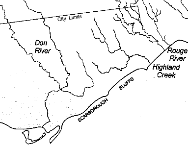
When we look at a map of the Toronto area that shows the rivers and streams, it is apparent that most flow from the north-west to the south-east. A notable exception is that both the Don and the Highland at one point take a significantly different direction, the Don turning west and the Highland turning east. They appear to be avoiding Scarborough Bluffs.

During most of the first half of the last glaciation the Wisconsinan Ice Sheet did not cover Toronto, but was located a bit to the north-east. The ice sheet had blocked the St. Lawrence, causing a high level lake similar to Lake Iroquois. Each summer, a large river fed by the melting ice flowed into this lake and dropped material that formed the Scarborough Formation (115-106,000 years ago) the Pottery Road Formation (106-75,000 years ago) and the Sunnybrook Drift (60-75,000 years ago) (seen in the Brickworks and at Scarborough Bluffs). This delta was big enough that the Wisconsinan Ice Sheet was not able to destroy it completely during its advanced to its maximum extent. This protected the Don Beds and so preserved the evidence of the warm interglacial stage.
When the Don River and the Highland Creek flowed again after the ice had left. their direct flow was blocked by the delta. In the case of the Don a baymouth bar formed in Lake Iroquois played a part, but the material in the bar came from, and it was laid down on top of, the great delta.
Other Pages in this Series
- Don Valley Brick Works Quarry - North Wall
- Before the Ice Age
- How The Glaciers Started
- Maximum Extent of the Ice Sheets
- The Story From The Lakes
- The Story of the Trees
- Early Stages of the Retreat of the Ice Front
- Drumlins and Flutings
- Lake Iroquois & its shore cliff
- The Wide Valley of the Lower Don
- Geology References
