2 km of Castle Frank Brook plus Cedarvale Stream 1.9 km and Forest Hill Stream 2.3 km
Cedarvale Reach lies in the former City of York from Arlington Avenue to Bathurst Street and again from Heath Street West to St. Clair Ave. West. From Bathurst to Heath it is in the former Village of Forest Hill. Two small tributaries are also described: Cedarvale Stream, which started just east of Bathurst Street and flowed west to Everden Road (near the Eglinton West Subway Station) and then south down into Cedarvale Park, and Forest Hill Stream which arose south west of Bathurst and Eglinton and flowed south-east and then south-west to join Castle Frank Brook near Lonsdale Road. The area is chiefly high class residential. Sanitary Sewage from the former City of York flows to the Humber Sewage Treatment Plant. That from the former Village of Forest Hill empties to the North Toronto Sewage Treatment Plant or to the Core Interceptor Sewer. Surface water flows by the Spadina Storm Trunk Sewer to Yellow Creek and thus to the Don River. This area is flanked by two streets that follow settlement roads and probably ancient native trails.
The best place to start walking the Cedarvale Reach is in Everden Park at the south-east corner of Eglinton and Everden Road, across from the Eglinton West Subway Station. The suggested route is about 2.7 km. Poplar and Spruce have been planted in this park. From Everden and Gloucester Grove, follow a small tributary, Cedarvale Stream, into Cedarvale Park. See the Cedarvale Stream page for details.
Click here to see sewers. Double click to remove.
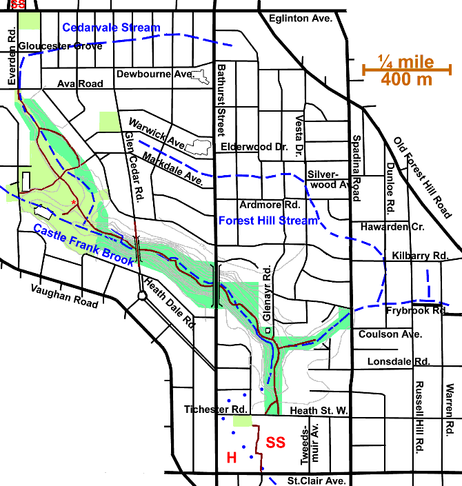
At the top of the slope above the Arena look down into Cedarvale Ravine. Castle Frank Brook flowed into the park from behind the Arena and met Cedarvale Stream. Follow this ravine down to Heath Street East. See the Cedarvale Ravine page for details.
Reaching Heath Street West, one can enter the north entrance to the St. Clair West Subway Station using tokens (the booth is only open Monday to Friday 7 a.m. to 5:30 p.m.) To reach main entrance to St. Clair West Subway Station or continue down Castle Frank Brook valley, one can go east to Tweedsmuir Ave.; then south and back west on St. Clair or, alternately, go west on Tichester Rd. (the continuation of Heath Street) to Lonsmount then S & E to St. Clair via small park, lanes and Loblaw’s parking lot. Cross St. Clair at the light at Wells Hill Ave. to continue down the next reach through Nordheimer Ravine.