Return to Don Channel Reach main page.
To see main sewers pass mouse over map.
Original course of Don River in light blue
Urbanization has had a great impact on the Don River watershed, but the maximum impact is here on this stretch of the Don River Valley between Gerrard and Queen Streets. The natural zone is not only constrained by the channelization, but also by transportation corridors and the proximity of industrial and residential development.
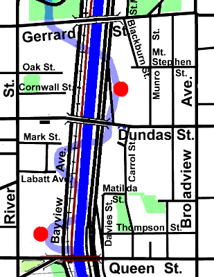
North of the Narrows, the valley broadens into parkland that stretches to the headwaters. While to the south lies the equally challenged tract stretching to Toronto Bay, plans are well underway to bring back some natural areas. In the West Don Lands Precinct, the low lying berm on which The Don River Park will be established is under construction. An Environmental Assessment is underway for the Don Mouth Naturalization and Port Lands Flood Protection Project. While the latter will include the channel proper up to Gerrard Street, any restoration beyond the edge of the channel will depend on other initiatives.
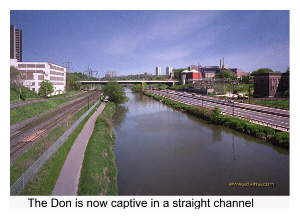
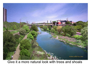
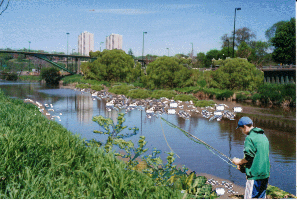
The Don Channel now and as it could be.
The Task Force to Bring Back The Don has a vision for this area that in addition to plans for the channel will look at the area back of the river. They started some years ago by obtaining a computer-enhanced view of a more natural riverbed (seen above), followed by a meeting to discuss possibilities with other interested people in March 2001. A draft plan was prepared and a final plan is expected shortly. In the meantime, those responsible for the restoration of the mouth were persuaded to include the channel proper up to Gerrard in their plans.
When the natural river bends were removed to straighten the river and ease the way for railroads, roads, power corridors, pipelines and barges, the soft, vegetated edges and the wetlands on the bottomland were removed. No thought was given to the survival of fish, birds, land animals and plants in an altered environment. They simply were considered irrelevant. With the development of the transportation corridor most buildings were turned away from the river and now present a blank back wall to the river. In effect the city turned its back on the river. The noise and pollution of the Don Valley Parkway dominate the landscape and repulse the senses.
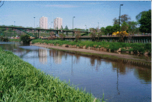
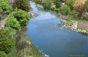
More pictures showing The Don now and what it could look like.
Correcting this will be difficult. We are stuck with the transportation corridor; however, there are signs of hope. The unnaturally wide river channel is making its own softer edge with several gravel point bars that attract water fowl during low flow times, and a few hardy trees on the river banks. From Riverdale to the Bay, it is proposed that meanders be created within the existing cross-section of the river, by enhancing these trends. There is a need to diversify the aquatic habitat and create a wildlife linkages and also improve human access. A 1994 report suggested that: “Initial analysis of the impact of any intrusions into the low flow channel on flood levels indicated that they would have to have a low profile and not take up more than about one quarter of the width of the river.” It went on to propose that a series of alternating point bars be spaced about 100 metres apart. On the east side, the bars would protrude eight metres into the channel and a continuous four metre corridor would be maintained. On the west side, four metre bars would placed between the east side bars. The maximum elevation on the point bars would be about half a metre above the average water level at the existing channel walls. At its tip each bar would be 20 cm above the water level. “The outer edge of the meanders would be protected by river stone and the top would be vegetated.”
Some areas such as the site of the former Don Incinerator were listed for special action. An enhanced path system to improve access was suggested. The Don Brewery, shown below, is an example of the industrial buildings that once lined this stretch of the Don. It is now being transformed into residential lofts. Ron Fletcher tells a story about the brewery business along the Don and the families involved on page 18 of “Over the Don.”
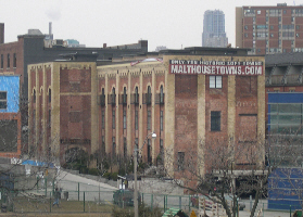
Don Brewery, December 27, 2006.
For pictures of the Gerrard Street Bridge and the Dundas Street Bridge go to Ravines Bridges.
On the east side, about two-thirds of the area is residential, nearly all of which is older (mostly humble Victorian) the remainder is public housing now in the process of redevelopment. There is a commercial strip along Broadview At Gerrard we find one of the city’s scattered China Town quarters. On the west side, old industrial buildings predominate, some of which have been or are being converted to residential. A cluster of high rise residential buildings lies north of Oak Street. There is fair tree cover dominated by Silver Maple along the older housing streets. Also noted there were White Birch, Ailanthus, Manitoba & Norway Maple, Linden, Siberian Elm, Mulberry, Yew, White & Red Cedar, and a Gingko.
The rest of the area has only light tree cover with some Manitoba Maple and other brushy trees. Crack Willow, Manitoba Maple and Ailanthus are found along the river bank. Converting the latter is to desirable native species is an ongoing goal of the Task Force to Bring Back The Don.
While originally this area drained directly to the Don River, direct access is now blocked by streets, railroads and The Don Valley Parkway; so most storm water must pass through various culverts and small storm sewers to reach the river. Sanitary sewage flows to the Ashbridge’s STP via the Interceptor Sewers.