Return to Don Channel Reach main page.
(Ataratiri cancelled March ‘92)
While the West Don Lands were part of the Town of York, they lie east of the original town plot and were used as park land until the 1830s when housing and industry started to intrude. This was part of the Corktown neighbourhood. They are currently in the throes of reconstruction. In May 2005, Toronto City Council approved the West Don Lands precinct plan, which outline a major redevelopment for this area. This will include 6000 new residences, of which 1200 units will be affordable rental housing; community parks and public space including the eight-hectare Don River Park; a new transit line that will be within a five-minute walk of all these new home; childcare centres, community centre, pool and an elementary school. Construction has started so this area is, for the time being, not accessible to the public. Residents are expected to start moving into early completed portions of the development in 2008. The new transit line is expected to be complete in 2009. The map shows the planned street grid and parks.
To see Points of interest and old course of the Don River pass mouse over map.
Click here to see sewers. Double click to remove.
The West Don Lands area is within walking distance of downtown, is right next to the Distillery District and has strong connections to the St. Lawrence and Corktown neighbourhoods. Community members have played an important role in the design and implementation of the West Don Lands, particularly in supporting high quality design, leading sustainability standards and making affordable housing an integral part of the new neighbourhood.
The Don River Park will be established on a low lying berm, which is the major flood protection feature of this development. This area has been flooded many times in the past so this is a significant issue. This berm together with widening the river and lengthening the CN rail bridge is expected to protect a significant part of downtown Toronto from flooding. A district energy system to provide heating and cooling to new waterfront neighbourhoods is being developed which will reduce costs and reduce overall air emissions.
These changes came about as a result of the setting up of the Toronto Waterfront Revitalization Corporation (TWRC) in 2001 as agreed by the three levels of government the Government of Canada, the Province of Ontario and the City of Toronto. West Don Lands were identified as one of the priority areas for early action. This collaboration has been effective due to the efforts of three agencies: the Ontario Realty Corporation, Toronto and Region Conservation and the Toronto Community Housing Corporation.
Being an old part of the city there are several historic points of interest: The Canary Restaurant was once the Palace Street School, one of the earliest public schools in the city. The Distillery District uses structures of Gooderham and Worts. The Toronto Rolling Mills and the Don Packing House are examples of Toronto’s former industry. On Eastern Avenue near Cherry Street is the site of the Blackburn house. Thornton Blackburn, an escaped slave, started the city’s first taxi business. The Don Station, now at Todmorden, was originally just south of Queen Street. Across the river, is the site of John Scadding’s home, now encircled by a DVP on-ramp.
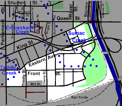
While originally this area drained directly or via Sumac, Crookshanks or Taddle Creeks to the Don River or Toronto Bay, now most storm water goes to the Don via a number of local storm sewers. Sanitary sewage flows to the Ashbridge’s STP via the Low Level Interceptor Sewer. Tree cover here is largely absent. Restoration will require a fair amount of tree planting.