1.4 km of Cudmore Creek, from Bayview Avenue south of Merton Street to where it meets the Don River near Pottery Road.
The portion north of Moore Ave. was in the former Town of Leaside; all of it was in the former Borough of East York. Sanitary sewage from Leaside goes to the North Toronto Sewage Treatment Plant a bit east of here in the Don Valley; the balance goes to The Ashbridges Bay Sewage Treatment Plant. While much of this reach has been drastically changed by road construction (Bayview Extension) and commerce (Loblaws), there is still a small ravine south of the CPR mainline tracks.
Start on Bayview Ave. a bit south of Sutherland Dr. and the pedestrian gate into Mount Pleasant Cemetery; find the walkway that leads east into Sandy Bruce Park. The low point on Bayview near this path hints at the former stream valley. While much changed by fill and construction, the park’s topography is characteristic of a former stream valley. The park is mostly open playground, but does have a few trees. A cluster of Linden, Elm and Norway Maple provides a shady corner in the south west and others scattered across the field furnish interest. They include a large old Red Oak, a couple of small Ginkgoes and some Colorado Spruce, Black Locust and Silver Maple.
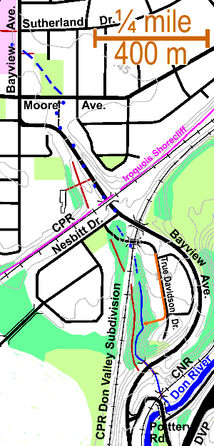
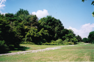
Cross Moore Ave. into the Loblaw’s shopping plaza and parking lot. We will meet several bits and pieces of Pottery Road, which used to run from here at Moore Avenue, down into and across the Don Valley to Mortimer and Broadview and served Cudmore’s pottery. One bit of Pottery Road divides this plaza. Follow Bayview south and under the CPR underpass to Nesbitt Drive, where there is a light that will aid in crossing this busy road. It is hard to distinguish the Bayview Avenue road cut from the former valley of Cudmore Creek, but if, along the way, one looks across to the west side of Bayview one sees a terrace with a wooded slope beyond. If one should visits this terrace one would find a bit of paved road connected to nothing. This is an abandoned piece of Pottery Rd. (Picture) The wooded slope is a bit of old woodland and include White and Red Oaks, Ash, Sugar and Manitoba Maples and Black Cherry. There are stairways from this terrace up to Bennington Heights Public School and down to the west side of Bayview. The Lake Iroquois shore cliff lies just north of the CPR which follows the level land below the shore cliff from “The Junction” to Millwood Road. A trail leads up along the old shore cliff from the south end of the terrace. This stretch of Cudmore Creek, from Moore to Nesbitt, is an example of how roads railways and shopping plazas show up along old creeks.
At Nesbitt walk west to True Davidson Drive, a new street, that leads to a new subdivision on the site of the former “Bayview Ghost”. A bit of the old ravine can be seen between Nesbitt, Bayview and True Davidson There is a cluster of Back Locust here. South of True Davidson (before the bridge) in the brushy woodland , there is another former bit of Pottery Road; this time unpaved.
Cross the bridge into the new subdivision and walk to the south end of True Davidson where there is an undeveloped park. This next stretch may be a bit difficult in places. Go west into the ravine and up the west side where there is another streach of old Pottery Road, now only a trail. Follow it along the west side of the ravine. One can go north (up) to the rail line and then south (down) to Bayview Avenue,
At the upper end the trees along the road are young and include Manitoba Maple, Sumac, and some Elms killed by Dutch elm disease. Then some young Oaks and White Birch are seen and eventually larger trees on the upper slope including Sugar maple, White and Red Oaks and Beech. The quality of this woodland is irregular. Trees noted in the valley included: Crack Willow, Beech, Red Oak, Elm, Sugar Maple, Ash, Black Locust, White Birch, Cottonwood, Manitoba Maple, Ironwood, Shrubs include Alternate Leaf Dogwood, Maple Leaf Viburnum, Hawthorn, Witch Hazel and Grape Vine There is a storm sewer outlet into the ravine serving the new development. Steam erosion has opened up a sandy slope that is probably a showing of the Don Formation, but no fossils were found.
Cross Bayview with care; this is a busy road. There is a bit of the ravine on the east side with Sumac, Elm, a cluster of Oaks. The path and the stream cross the CNR at Pottery Road. There is a possible site for wetland restoration ( wet meadow) under the Hydro transmission line. Cudmore Creek enters The Don just east of the Pottery Road bridge through a small woodland area of Crack Willow, Sumac and Manitoba Maple.