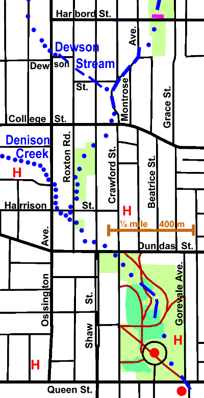
2 km of Garrison Creek plus the tributary Dewson Stream 0.6km
Here we trace the course of the former creek from Harbord Street to Queen Street through a moderately treed, older residential area. There are some commercial areas, particularly along major streets. Parks along the way include Harbord Park. Fred Hamilton Park, Roxton Road Parkette, Trinity Bellwoods Park and some tiny parkettes with gardens and monuments marking the former course of Garrison Creek. One of The City of Toronto Discovery Walks, “Garrison Creek” follows this reach. Sanitary trunk sewers follow the old stream taking the sanitary waste to the Mid Toronto and lower Interceptor Sewers, which carrry it to theAshbridges Bay Sewage Treatment Plant. Some storm and combined sewer overflow water flows to Exhibition Park where it is held temorarily in the Western Beaches Storm Water Storage Tunnel. The balance flows to a combined sewer overflow outlet at the west end of Toronto Bay.
Click here to see sewers. Double click to remove.

Start in Harbord Park, a small neighbourhood park with some trees (Norway Maple, Linden, Honey Locust, & Ash), a playground and an open recreational area. The ravine has been completely filled here. Leave by the SW corner by Montrose Public School. Here we see the first of three monuments with gardens marking the course of Garrison Creek along Crawford St. which may be followed south. This street is in a valley marking the course of the former creek. A small tributary, Dewson Stream, joined Garrison Creek just south of Dewson St.
Dewson stream, a short (0.6 km) tributary of Garrison Creek gets it name from Dewson Street. Mary Anne Dewson was the wife of George Taylor Denison II, an early land owner in this area who built the great house, Rusholme.
It started about where Hepbourne St. meets Ossington Ave. and flowed south and east to cross Dewson and Roxton and Dewson and Shaw in a distinct valley. It traversed what is now a moderately treed residential area.
Garrison Creek crossed College St. just west of Crawford and flowed south west to about Roxton Rd. and Harrison St. The stream location is hazy in this stretch, as its ravine has been filled. Follow it across the shopping plaza and into Fred Hamilton Park, which has a fair tree cover: mostly Norway maple with some Silver Maple, Linden, Walnut and Ash. Cross the park and down Roxton Rd. past Harrison to an open grassed slope on the east side of the street, Roxton Rd. Parkette. This open park has some recently planted trees: Linden, Red Oak & Honey Locust. The sewer is buried under much fill here. Note how the Harrison has been built up, between Roxton and Ossington, in front of the old apartment building on the south side.
Denison Creek joined Garrison Creek a little south of Harrison. Walk up though the parkette to the lane, south to Dundas St. and east to Shaw St. Oak Hill, the residence of Major-General Aeneas Shaw,” a note loyalist pioneer and soldier in the American War of Independence and the War of 1812, was located close to the inter section of Harrison and Crawford.
Cross into Trinity Bellwoods Park The low spot marking the stream crossing is close to Crawford St. The park west of Crawford has two interesting monuments: one marking 2001, the Year of the Volunteer, the other of Simon Bolivar. Trees in this part include: numerous Norway Maple plus some Sugar Maple, Honey Locust, Linden, Ash, Norway Spruce, Catalpa and Pin Oak. Past Crawford one can enter a bit of the valley remaining. The bits of woodland on the valley slopes include quite a few Norway and Sugar Maples, plus Black Locust, Ash, Linden, Honey Locust, and a few recently planted Norway Spruce, White Pine and Red Oak. After the bit of valley ends one crosses a circular road that marks where Trinity College stood before it was moved to the University of Toronto Campus. There are a number trees, some quite interesting, in this circle including: Ginkgo, Dawn Redwood, Ash, Linden, Siberian & Red Elm, Honey Locust, Red & Norway Maple, Bronze Beech, Mountain Ash, Mulberry and Hackberry. South of the circle a road runs to Queen Street where the gate to the original Trinity College still stands. Gore Vale, the fine house built by Duncan Cameron in 1817, stood east of the circle, near Gorevale Ave. In 1812, Cameron commanded the York Volunteers at the battle of Queenston Heights.
Garrison Creek crossed Queen St. at the low spot at the corner of Gorevale. Cross Queen and continue along the Fort Reach.
