The top 1.7 km of Burke Brook, Downsview to Highway 401 and Bathurst
Burke Brook arose in the Downsview area not far from the Wilson Heights Blvd. / Allen Road interchange. Its route crosses Highway 401 at Bathurst Street just south of Wilson Avenue. This reach was entirely in the former City of North York. This is an area of low relief, but the former creek’s route can be traced through changes in slope with the help of older maps. There is also an old drainage ditch that at one time diverted the stream for a distance. Sanitary Sewage flows to the Main Pollution Control Plant via the West Don Trunk Sewer and storm water to the West Don via the Wilson Heights Storm Trunk Sewer. It lies close to the upper reach of Mud Creek, which is also shown in the map below.
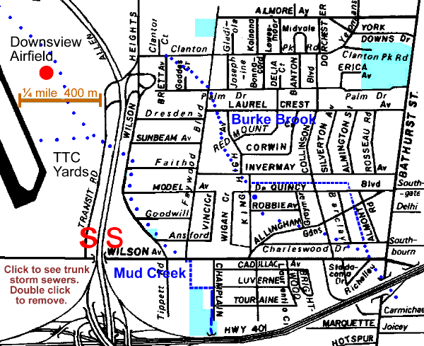
To trace this reach on the ground, start at Clanton Park Road and Brett Ave. and go south-east to Faywood Blvd. and Palm Dr.; the stream would have flowed through this block. Go south on Faywood to Laurel Crest Avenue, east to King High Ave. and walk south; the stream would have flowed south just west of King High to De Quincy Blvd.
A resident told me: “There used to be a footbridge on King High between Invermay and DeQuincy (this was in 1959). It was paved years later to connect the roads. Under the bridge ran a ditch, usually with water, heading due east between the backyards of the south side of Invermay & the north side of DeQuincy.”
Between Invermay Ave. and De Quincy you can still see this ditch, which diverted this stream, and follow it east past Collinson Blvd. and then south between Almont Rd. and Barclay Rd. to Charleswood Dr. Vegetation noted along this ditch included: Siberian and White Elms, Manitoba, Norway and Silver Maples, Apple, Ash, Basswood, Buckthorn, Virginia Creeper, Grape, Golden Rod, Garlic Mustard, Thistle, Sow Thistle, Nightshade and Raspberry. Lots of garbage and a side drain to a catch basin on Invermay were also noted.
The route of the original stream is hazy, but apparently flowed from De Quincy just west of King High SE across King High, across Robbie Ave. to the corner of Allingham Gdns. and Graymar Ave. and on past Collinson to the corner of Charleswood and Barclay, A willow that may have grown beside this stream can be seen in the centre of the block west of Barclay. Burke Brook crossed Wilson Avenue just west of Bathurst and Bathurst at Highway 401. The next reach of Burke Brook is the Avenue Road Reach.