1.8 km of Mud Creek from Yonge St to Moore Ave.
This reach passes first through residential city streets in the former Town of North Toronto and then through Mount Pleasant Cemetery. Most storm water now flows to the Vale of Avoca and Yellow Creek. Sanitary sewage flows via the Avenue Manor Combined Trunk to the North Toronto Sewage Treatment Plant.
Click here to see sewers. Double click to remove.
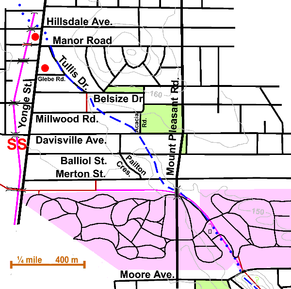
Mud Creek crossed Yonge Street at Hillsdale Avenue. Today, it is hard to imagine this as a treacherous swamp described as a “stretch of very wild and difficult land” where Yonge Street was made barely passable by a stretch of corduroy road. Scadding describes this stretch of Yonge Street as very different to the today’s scene: “We happen to have a very vivid recollection of the scene presented along this particular section of Yonge Street, when the woods, heavy pine chiefly, after having been felled in a most confused manner, were being consumed by fire, or rather while the effort was being made to consume them. The whole space from near Mr. Walmsley’s potteries to the rise beyond which Eglinton is situated was, and continued long, a chaos of blackened timber most dismaying to behold.”
Walk south to Manor Road, east to Tullis Drive, then south to Belsize Drive. Tullis follows the course of Mud Creek. Today, the Avenue Manor Combined Truck Sewer flows under this street. Notice fragments of creek banks to the right and left and the curvature of road between them. Passing Glebe Road, we are reminded of the time when parcels of land, known as glebes, were reserved for the “established church.”
At the bottom of Tullis, cross to the south side of Belsize and take the footpath to Millwood Road. High fences and dense foliage in summer make it difficult to see Mud Creek Ravine from this path. At Millwood, walk east into the ravine, where you will notice differences in the sizes and shapes of the yards on the north side of the street. At one time, Davisville Avenue was accessible by paths through of the Salvation Army property. Walk east to Acacia Road and south to where Mud Creek crossed Davisville, then walk west uphill to Pailton Crescent, then south. Pailton follows the west top of the ravine. Notice several interesting sculptures along this street.
Look eastward on Balliol Street to the low point in the street, where an apartment building sits directly over the riverbed. Each spring, a lake forms in the parking lot. The large willows behind the building are clues to the underground watercourse. Flowing eastward under Balliol, a main trunk sewer carries all the sanitary sewage from the former Town of North Toronto, the former Village of Forest Hill and parts of the former City of North York to the North Toronto Sewage Treatment Plant in the Don Valley. The Avenue Manor Combined Truck Sewer joins it here at Pailton. Follow south along Pailton to Merton Street, then east to Mount Pleasant Road. The creek flowed across Merton and through the former Dominion Coal Yard.
Norway maples dominate the tree cover, but in places, silver or Manitoba maples appear. Other trees include honey locust, ash, linden, Austrian pine, crabapple, Colorado spruce, catalpa, mulberry, elm, white birch, Scots pine, cedar, European beech, red oak, ailanthus, magnolia, and Kentucky coffeetree.
Cross Mount Pleasant at Merton, then proceed south over the bridge crossing the Beltline. The Belt Line Park west of Yonge Street follows the abandoned bed of the former Belt Line Railway. In the next few years, the park will be extended east into Mount Pleasant Cemetery, running south of and parallel to Merton Street, along the south side of the former Dominion Coal property, and under Mount Pleasant Road through the existing tunnel. East of Mount Pleasant, the Belt Line Trail will follow the course of Mud Creek through the cemetery. Notice a small ditch behind the apartment building on the south of Merton. This tiny fragment of wetland at this corner is fed by ground water and run-off from rainstorms and contains a few elms, beech, willows and small water loving plans like scouring rush (Equisetum sp.), forget-me-not, and buttercups.
Until the Belt Line Trail is extended east, we will have to walk south on Mount Pleasant to the gate were we can enter Mount Pleasant Cemetery. Walk east to the Cemetery headquarters building, observing the fine trees, many of which have labels telling the common and scientific names.
Just north of the headquarters, notice the bridge abutment that once supported a roadway across the tracks of the Beltline railway. Looking east from this abutment, imagine the ravine through which Mud Creek flowed and through which the railway line ran. Soil from the Toronto Subway excavation in the 1950s obliterated much of its depth. Recently, the cemetery built a garden and mausoleum here with spots for the scattering of ashes and niches for the placement of funerary urns.
Walk down into and through the garden, then south along the main path. At the sewer grate access, listen to the sound of ground and stormwater resonating from the main storm trunk sewer. This water, however, is not Mud Creek water for it has been diverted elsewhere, but that of the upper Cudmore Creek watershed passing through this storm trunk sewer. When the cemetery part of Cudmore Creek ravine was completely filled with subway construction earth, upstream water was diverted over to the Mud Creek ravine. The outlet of this sewer will be seen later in the Moore Park Ravine. See also Discovery Walks.
Enjoy planted trees, shrubs and flowers in season as you continue south along the main path to leave the cemetery through the attractive pergola-like pedestrian gate on Moore Avenue. Cross Moore at the stop sign to the west, return east, then down into Moore Park Ravine.