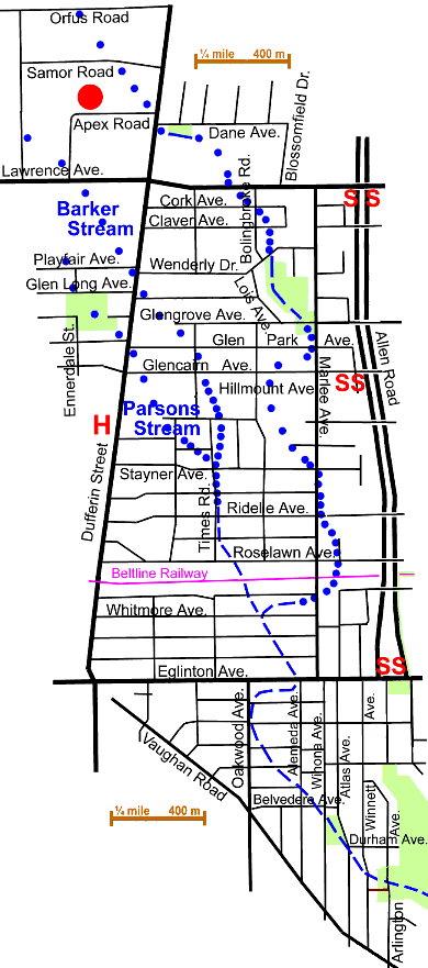
4.6 km of Castle Frank Brook plus Parsons Stream 2 km and Barker Stream 1.8 km
Castle Frank Brook rose in three small streams in the Dufferin & Lawrence area. One can still see traces of the main or easterly source stream in two small parks: Dane Parkette (on Dane Ave. east of Dufferin St.) and Wenderly Park (between Marlee & Lois Avenues). A trace of the westerly stream, Parsons Stream, is noticeable in Glen Long Park at Ennerdale St. & Glen Long Ave. The old streams can be traced through the small ravines that cross this area and followed south into the Cedarvale ravine at Arlington Avenue, near the community centre. The Fairbank Reach lay in what became the former Cities of North York and York. The subwatershed to the west is that of Black Creek. The Beltline Railway ran across this reach.
The surface water in the part north of Briar Hill Ave. (in the former City of North York) now empties into Black Creek via the North York Trunk Storm Sewer. In the southern part of this reach it flows to the Spadina Storm Trunk Sewer. Sanitary sewers west of Dufferin flow to the Humber Sewerage Treatment Plant. Most of the sanitary sewers east of Dufferin are connected to the North Toronto Sewage Treatment Plant. This reach is largely residential with some industry west of Dufferin and along the former Beltline Railway. Commercial areas exist along arterial streets.
To trace this reach, one could start at Yorkdale Secondary School on Orfus Road, northwest of Dufferin & Lawrence. If one old map is correct, the main or easterly stream started here. The topography is nearly flat so the actual course is very hazy. This is the site of the former Barker Airfield. Go south and east to Dane Avenue, crossing Dufferin with the light, at Samor Road. Walk east on Dane and enter the small Parkette on your right. A ditch left from this stream can be seen on a map produced from air photos taken in 1969. A bit of this ditch is visible in the parkette and in adjacent industrial land.
Click here to see sewers. Double click to remove.

Continue east on Dane and south on Blossomfield. Cross Lawrence Avenue at Bolingbroke Rd. and follow Bolingbroke to Wenderly Drive. Enter Wenderly Park and walk through this park to Marlee Ave. and Glen Park Ave.
Wenderly Park is mostly open grass with some trees including: Norway Maple (both normal & Crimson King), Austrian Pine, Crab Apple, Crack Willow, Mountain Ash, Honey Locust, Hackberry, Elm, Linden, several planted Red Oaks and Ash, Weeping Willow, Silver Maple, European Larch, Scots Pine, Birches, more Honey Locust, Norway Maple & Ash.
Follow Marlee south to Eglinton Ave. noting the dips in the streets to the west or the east. At Stayner Castle Frank Brook crossed Marlee and flowed south just east of Marlee to the Beltline Railway. The Fairbank Station was located just west of Dufferin Street. After crossing the Beltline Castle Frank Brook flowed south west to Whitmore Ave. half a block west of Marlee, where it met the waters from the westerly and central source streams, Parsons Stream 2 km and Barker Stream 1.8 km, which had joined near Stayner Ave. and Times Road. A trace of Parsons Stream, the westerly one, is noticeable in Glen Long Park south of Ennerdale St. & Glen Long Ave. There is a fine Red Elm on Ennerdale St. Barker Stream, the central source started in or near the former Barker Airfield on Lawrence Avenue. No parks or natural areas are left along its course.
From Whitmore, Castle Frank Brook flowed south and east to Alemeda Ave. and Eglinton Ave. Cross Eglinton Avenue at the lights and go west to Oakwood Ave. Watch the stream valley as you go south six blocks on Oakwood and two blocks east to Winona Ave. & Belvedere Ave. It is quite visible here. Walk south and east through small park to Durham Ave. Go east on Durham Ave. to Winnett Ave.and south about a half block to a foot path to Arlington Ave. and the entrance to Cedarvale Park. A warning: this is easy on foot, but a complicated traffic maze makes vehicle travel difficult.
Continue into Cedarvale Reach past arena.
