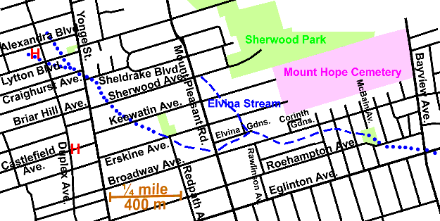
2.5 km. of Walmsley Brook and Elvina Stream .6 km
Most (1.7 kilometres) of this reach of Walmsley Brook flowed through the former Town of North Toronto. The last 800 metres crossed bit of the Township of North York, half of which was added to the former City of Toronto in 1967. It started in two small streams near Duplex Ave. and Alexandra Blvd. which joined, crossed Yonge Street at Sheldrake Blvd. and flowed south-west to Mount Pleasant Road and Broadway Ave. From there it followed Broadway Ave. for several blocks till it swung south through Roehampton Avenue Park to cross Bayview and Eglinton Avenues only slightly north-east of that intersection. It is joined by Elvina Stream at the end of Elvina Gnds. Sanitary Sewage flows to the North Toronto Sewage Treatment Plant in the Don Valley via the Forman Yonge Combined Sewer. Much of the storm water in the north-west end has been diverted to Burke Brook and in the south to Mud Creek. The area is residential except for some retail strips along main arteries. Trees noted along this reach included Norway Maple, White Pine, Honey Locust, Linden, Silver Maple, Horse Chestnut, Sugar Maple, Austrian Pine, White Birch and Elm.
Click here to see sewers. Double click to remove.

To walk this reach, start at Alexandra Blvd. and Yonge Street and walk west to Duplex Ave. A slight dip about mid block the route of the east streamlet which is shown a starting in the block to the north. Walk south along Duplex to Lytton Blvd., noting the Snyder farmhouse at #744, set well back from the street. It once stood at the end of a orchard bordered lane off Yonge St. A low trough in the terrain at Duplex and Lytton tending to the north-west marks the west streamlet; which may have started a couple of blocks north-west. St. George’s United Church stands at the Southwest corner. Walk back to Yonge along Lytton. Dips in this block suggest that the two streamlets joined just south of Lytton. One might rest in the playground behind electric building at the corner of Yonge and Lytton. The streams are not well marked and there may be some question about the actual location of the source. (See Note)
Walmsley Brook crossed Yonge Street between Craighurst Ave. and Sheldrake Blvd. Cross at lights Briar Hill/Sherwood and walk south to Keewatin Ave. noting dips along Sheldrake & Sherwood to the east. Walk east on Keewatin to Redpath Ave. Parkette and south through park to Erskine Ave. Several apartment buildings have been built over the brook’s route here, as has happened in many areas. A distinct valley starts at Erskine and Redpath. Walk east on Erskine to Mount Pleasant Road. At Mount Pleasant one could walk north to explore the source of Elvina Stream or south to continue along the main stream. The Walmsley Brook Valley is quite clear where it crosses Mount Pleasant at Broadway Ave. then swung slightly north to the end of Elvina Gdns. It is suggested that walkers follow Broadway Ave. east as far as McBain Ave. For the first block it can be glimpsed between the houses to the north. It crosses to the south of Broadway a bit east of Rawlinson Ave. and can noted by the deep dips in the streets running south. The terrain has become quite hilly. For 400 metres, from opposite Corinth Gdns. to Roehampton Avenue Park, it passes though the former City of North York. The last 400 metres, from Roehampton Avenue Park to Bayview, crossed bit of the Township of North York that was added to the former City of Toronto in 1967 (?).
At McBain Ave. turn south and into Roehampton Avenue Park. While much of the valley has been filled in this park, it can be seen coming in from the west. Trees in this park include large Cottonwoods, Norway Maple, Linden, Honey Locust and Elm. Walk eastward through the Dominion Store parking lot to corner Bayview Ave and Eglinton Ave. A great deal of fill has placed in this part of the valley. Walmsley Brook is shown crossing the north-east corner in early maps an can be seen crossing a muddy Bayview in an early picture. Cross this intersection to continue along the Leaside Reach.
Elvina Stream 0.6 km, started near Mount Pleasant Road and Sheldrake Blvd. and flowed South to join Walmsley Brook at Elvina Gardens. As one walks south on Mount Pleasant Road one can see distinct dips along Keewatin Ave. and Erskine Ave. to the east. One can walk east on Erskine to Elvina Gardens and back out to Mount Pleasant.
